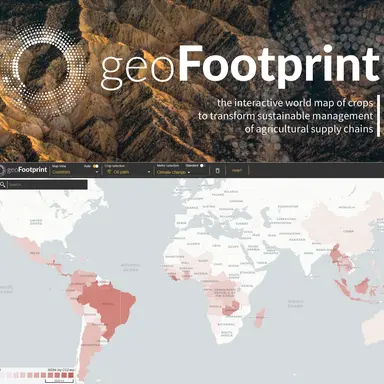
Sustainability consultancy agency Quantis launches geoFootprint, the first tool using satellite image data to visualise the environmental impact of major agricultural crops on an interactive world map, in order to make more relevant and scientifically sound decisions on sustainable development. In addition to the main crops supporting the global food system, geoFootprint provides insights into other crops related to, among others, the chemical and cosmetics industries.
Cosmetic companies are often limited in understanding the impact of crops in their supply chain due to the complexity of the data. geoFootprint now enables instantaneous capture of geographically specific insights and testing and simulation for faster, science-based decision making.
“While agriculture is one of the biggest contributors to the climate and biodiversity crisis, it is also one of the most promising solutions. geoFootprint enables companies to reduce the environmental footprint of crops in their supply chains by providing information that was previously almost impossible to obtain,” says Xavier Bengoa, geoFootprint project manager.
The geoFootprint tool
geoFootprint combines satellite image data with environmental measurements to enable users to visualise the footprint of major agricultural crops on an interactive high-resolution world map.
Companies and stakeholders throughout the supply chain can instantly simulate the environmental footprint of crops, enabling faster, better informed and more sustainable decisions.
This new tool opens up a new information channel, bringing upstream visibility of farm impacts (from deforestation, fertiliser use, irrigation, land management and other factors) directly to strategic decision-makers.
In addition to providing information to guide sustainability decisions, geoFootprint enables users to assess risks related to climate change, the presence and quality of water, soil health …


 avant d'acheter !")


